Looking for design inspiration? Browse our curated collections!

Boundary: Bleed area may not be visible.

The watermark at the lower right corner of the image will not appear on the final product.

by Paul Fearn
$13.50
This product is currently out of stock.
Style
Size
Image Size
Product Details
The Center for Disease Control has recommended the use of cloth face masks to help fight the spread of COVID-19.
This face mask is made from 100% polyester and includes two woven, elastic loops for a comfortable, one-size-fits-all fit.
Please note - this is NOT a surgical grade mask. It is not intended for any medical or commercial uses, whatsoever. It is a simple, cloth mask designed for everyday use to cover your mouth when out in public. The mask should not be used in any medical or surgical setting.
We make no warranties that the mask prevents infections or the transmission of viruses or diseases.
Design Details
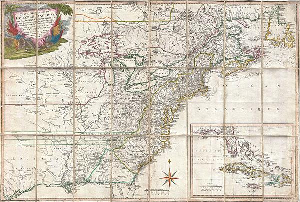
This is an important and extremely rare 1779 case map of the English colonies in in North America at the height of the American Revolutionary War.... more
Ships Within
5 - 10 Business Days
Average Rating (4.06 Stars):


Lisa Rose Musselwhite
March 12th, 2024
looks great
Lisa Rose Musselwhite
March 12th, 2024
looks great
Lisa Rose Musselwhite
March 12th, 2024
this came out very nice
Karen Kummer
June 7th, 2023
Very nice
Kim Moore
April 30th, 2023
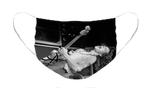
Love this guy.very cool looking masks
Kim Moore
April 29th, 2023
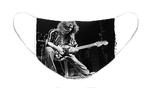
Who doesn't love Eddie?
This is an important and extremely rare 1779 case map of the English colonies in in North America at the height of the American Revolutionary War. Focusing on the English Colonies, this map covers the eastern part of North America from the Hudson Bay to the Gulf of Mexico, extending westward as far as modern day Galveston. Rene Phelippeaux and Brion de la Tour issued this map following the 1778 signing of the Treaty of Alliance between France and the fledgling United States, which brought the American Revolutionary effort to the attention of the French public. Cartographically this map is based upon the important John Mitchell map of 1755. As a whole it presents the colonies in superb detail, identifying cities and towns, forts, roads, Indian villages and tribal territory, and coastal shoals and banks. Curiously this map attempts to offer both a French and an English mapping of the region. Phelippeaux presents French Louisiana extending eastwards as far as the Appellation Mountains and...
My passion is Photography and Aviation or is that Aviation and Photography ! I hope you enjoy my photographs.

Our return policy is very simple:
If you're not happy with a purchase that you made on Pixels.com, for any reason, you can return it to us within 30 days of the order date. As soon as it arrives, we'll issue a full refund for the entire purchase price. Please note - Pixels does not reimburse the outgoing or return shipping charges unless the return is due to a defect in quality.
Pixels sells thousands of pieces of artwork each month - all with a 100% money-back guarantee. We take great pride in the fact that hundreds of thousands of artists have chosen Pixels to fulfill their orders, and we look forward to helping you select your next piece!
All face masks ship from our production facility within 5 - 10 Business Days of your order.
$13.50


There are no comments for 1779 Phelippeaux Case Map of the United States during the Revolutionary War. Click here to post the first comment.