20% off all products! Sale ends tonight at midnight EST.


The watermark at the lower right corner of the image will not appear on the final product.

by Paul Fearn
Regular Price: $28.00
20% Off (Sale Ends in 2 Hours)
$22.40
Design Location
Color
Image Size
Product Details
Our Bella / Canvas t-shirts are made from a 50% cotton / 50% polyester blend and are available in five different sizes. All t-shirts are machine washable.
Design Details
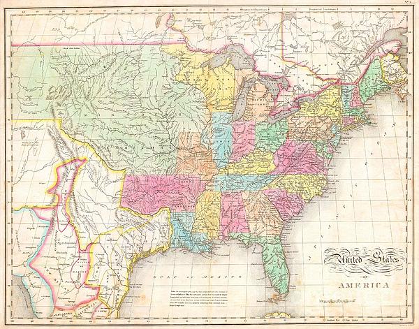
One of the most important American maps of the United States to appear in the early 19th century. Depicts the United States and Mexico roughly from... more
Ships Within
1 - 2 business days
Average Rating (4.34 Stars):


Simon Brown
April 13th, 2024

Great but Jaws fans saying it's spelt Pippit
Nope Nah
April 10th, 2024

Super high quality print, very happy with my purchase !!
Colleen Barch
April 10th, 2024

They were great!!!
Ellie Crabtree
April 9th, 2024

I was sent the wrong color.
Ellie Crabtree
April 9th, 2024

Image was crooked on the tshirt.
Deborah Nadge
April 8th, 2024
The artist is my son and is very talented. In high school he was accepted by Chicago Art Institute but couldn’t afford the tuition. He graduated from Fredonia State University with a Fine Art degree.
One of the most important American maps of the United States to appear in the early 19th century. Depicts the United States and Mexico roughly from the Atlantic to the region immediately west of the Rocky Mountains, including the massive Missouri Territory, Texas and parts of Mexico. This map was produced by the joint efforts of three important American mapmakers: John Melish, Benjamin Tanner, and Mathew Cary. It had its origins in Melish’s 1812 pocket format map of the United States. Over the following fifteen years the map would be updated, revised, and improved for various reissues. The current example is from Carey and Lea’s Atlas . Referencing the cartographic and exploratory work of Lewis and Clark, Pike, and Major Long, this map attempted to give an accurate picture of the western United States. Shows both the newly formed state of Missouri and the massive Missouri Territory. This extraordinary tract of land extended form the Mississippi River westward off the edge of the ma...
My passion is Photography and Aviation or is that Aviation and Photography ! I hope you enjoy my photographs.

Our return policy is very simple:
If you're not happy with a purchase that you made on Pixels.com, for any reason, you can return it to us within 30 days of the order date. As soon as it arrives, we'll issue a full refund for the entire purchase price. Please note - Pixels does not reimburse the outgoing or return shipping charges unless the return is due to a defect in quality.
Pixels sells thousands of pieces of artwork each month - all with a 100% money-back guarantee. We take great pride in the fact that hundreds of thousands of artists have chosen Pixels to fulfill their orders, and we look forward to helping you select your next piece!
All t-shirts ship from our production facility within 1 - 2 business days of your order.
$22.40


There are no comments for 1823 Melish Map of the United States of America. Click here to post the first comment.