Looking for design inspiration? Browse our curated collections!


by Paul Fearn
$28.00
Design Location
Color
Image Size
Product Details
Our Bella / Canvas t-shirts are made from a 50% cotton / 50% polyester blend and are available in five different sizes. All t-shirts are machine washable.
Design Details
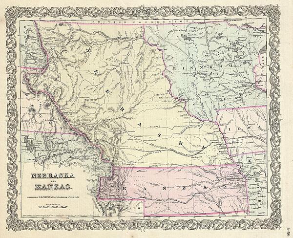
A beautiful 1855 first edition example of Colton's map of Nebraska and Kansas. This is most probably the rarest and most desirable of all Colton... more
Ships Within
1 - 2 business days
Average Rating (4.34 Stars):


Suzanne Hale
April 19th, 2024

Very original shirt, lots of compliments- great fit.
Dana Frederickson
April 19th, 2024

This is an excellent t-shirt! An excellent view of an SAS Connect Airbus A320-251N coming in for a landing! I especially wanted to buy this t-shirt because I am of Swedish descent! Excellent photography and artwork!
Dana Frederickson
April 19th, 2024

This is an excellent t-shirt! An excellent view of a P I A Boeing 777 coming in for a landing! The t-shirt came out great! Excellent photography and artwork!
Dean Will
April 18th, 2024

Very pleased with the item!! But wrong color.
Simon Brown
April 13th, 2024

Great but Jaws fans saying it's spelt Pippit
Nope Nah
April 10th, 2024

Super high quality print, very happy with my purchase !!
A beautiful 1855 first edition example of Colton's map of Nebraska and Kansas. This is most probably the rarest and most desirable of all Colton atlas maps. Based on earlier wall map produced by Colton and D. Griffing Johnson, this map details the regions between the Great Salt Lake and Iowa and between the Canadian Border and New Mexico. Covers territorial Kansas and Nebraska as well as parts of adjacent Minnesota, Iowa, Missouri and Utah. Shows Nebraska in its full territorial glory extending from the 40th parallel to the border British America or Canada. This massive and ephemeral territory covered much of what is today Nebraska, Wyoming, Montana, Colorado, North Dakota and South Dakota. Nearby Minnesota is also exceptionally large embracing all of the territory between Wisconsin and the Missouri River. When this map was printed Nebraska and Kansas had only recently been opened for settlement. Both regions were sparsely inhabited by the diverse yet powerful Indian nations of Comanch...
My passion is Photography and Aviation or is that Aviation and Photography ! I hope you enjoy my photographs.

Our return policy is very simple:
If you're not happy with a purchase that you made on Pixels.com, for any reason, you can return it to us within 30 days of the order date. As soon as it arrives, we'll issue a full refund for the entire purchase price. Please note - Pixels does not reimburse the outgoing or return shipping charges unless the return is due to a defect in quality.
Pixels sells thousands of pieces of artwork each month - all with a 100% money-back guarantee. We take great pride in the fact that hundreds of thousands of artists have chosen Pixels to fulfill their orders, and we look forward to helping you select your next piece!
All t-shirts ship from our production facility within 1 - 2 business days of your order.
$28.00


There are no comments for 1855 Colton Map of Kansas and Nebraska . Click here to post the first comment.