Looking for design inspiration? Browse our curated collections!

Boundary: Bleed area may not be visible.


by Paul Fearn
$25.00
Size
Image Size
Product Details
Purchase a tote bag featuring the photograph "1855 Colton Map of the West Indies" by Paul Fearn. Our tote bags are made from soft, durable, poly-poplin fabric and include a 1" black strap for easy carrying on your shoulder. All seams are double-stitched for added durability. Each tote bag is machine-washable in cold water and is printed on both sides using the same image.
Design Details
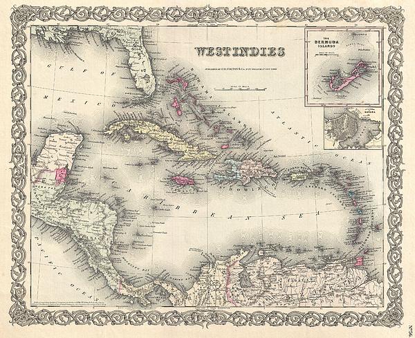
A beautiful 1855 first edition example of Colton's map of the West Indies. Centered on Santo Domingo (Hispaniola), this map extends north to include... more
Ships Within
2 - 3 business days
Average Rating (4.85 Stars):


Laurie Bame
April 24th, 2024

This bag is very sturdy and well made. The colors are vibrant and magical. I love this bag!
Colleen ONeill Nice
April 19th, 2024

Karen Cattel is a special artist and her whimsical art looks great on the two sturdy totes I purchased. One is a gift for a friend and the other is for me. I love them.
Janie McKinley
April 19th, 2024

I so appreciate being able to have this old-fashioned outdoor dinner scene on a tote bag. It is adorable. Thank you for making it available.
Sandra Johnson
April 18th, 2024

I noted that the color came out differently on this size of bag, it is distinctly more purple. I happen to love that color also--the larger size has perfect color, exactly like the photo. I love both of my bags.
Sandra Johnson
April 18th, 2024

the bags are lovely, a nice weight, and this big one is perfect color wise.
Susan Miller
April 12th, 2024

Quite beautiful!
A beautiful 1855 first edition example of Colton's map of the West Indies. Centered on Santo Domingo (Hispaniola), this map extends north to include the to cover all of Florida, south as far as Panama Bay and northern South America, and east as far as Barbados and the Windward Islands (Antilles). Identifies the island of San Salvador or Cat Island in the Bahamas as the site where Columbus supposedly landed on October 12 of 1492. Colton also identifies the site off the southern shore of Santo Domingo where Sir John Duckworth defeated the remainder of the French fleet following the battle of Trafalgar. Like most of Colton's North America maps, this map is largely derived from an earlier wall map of North America produced by Colton and D. Griffing Johnson. Colton identifies various cities, towns, forts, rivers, rapids, fords, and an assortment of additional offshore and topographical details. Map is hand colored in pink, green, yellow and blue pastels to define national and regional bound...
My passion is Photography and Aviation or is that Aviation and Photography ! I hope you enjoy my photographs.

Our return policy is very simple:
If you're not happy with a purchase that you made on Pixels.com, for any reason, you can return it to us within 30 days of the order date. As soon as it arrives, we'll issue a full refund for the entire purchase price. Please note - Pixels does not reimburse the outgoing or return shipping charges unless the return is due to a defect in quality.
Pixels sells thousands of pieces of artwork each month - all with a 100% money-back guarantee. We take great pride in the fact that hundreds of thousands of artists have chosen Pixels to fulfill their orders, and we look forward to helping you select your next piece!
All tote bags ship from our production facility within 2 - 3 business days of your order.
$25.00


Norman Johnson
Congratulations on your sale.