Looking for design inspiration? Browse our curated collections!

Boundary: Bleed area may not be visible.


by Paul Fearn
$35.00
Size
Orientation
Image Size
Product Details
Our luxuriously soft beach towels are made from brushed microfiber with a 100% cotton back for extra absorption. The top of the towel has the image printed on it, and the back is white cotton. Our beach towels are available in two different sizes: beach towel (32" x 64") and beach sheet (37" x 74").
Don't let the fancy name confuse you... a beach sheet is just a large beach towel.
Design Details
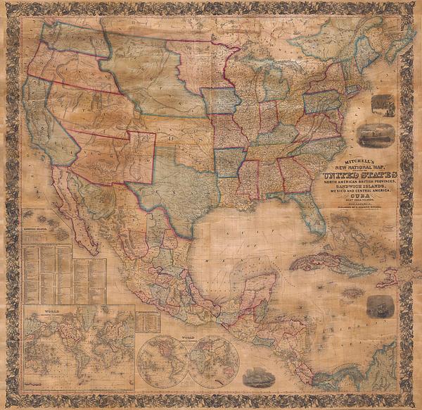
This is the first edition of Mitchell’s important 1856 wall map of the United States, Mexico and the West Indies. Depictss the entire nation from... more
Care Instructions
Machine wash cold and tumble dry with low heat.
Ships Within
1 - 2 business days
Average Rating (4.04 Stars):


Thomas Carroll
April 24th, 2024

Beautiful detailed movie themed towel!
Leesa Odom
April 16th, 2024

I bought this for my grandson. He fell in love with it. He even slept with it. It is a super good quality. Very impressed with image on the towel.
Kenneth Figueroa
April 13th, 2024

So it’s a gift for my dad and haven’t gave it to him yet but we FaceTime and he loved it … I was so worried about ordering here cuz never heard of the company but I’m so glad I did and it came out perfect perfect perfect.
Michele Long
April 13th, 2024

Super happy how print came out, but looks a little less vibrant even after just a cool water quick wash. Still nice looking, but would have preferred the vibrancy to have remained.
Michele Long
April 13th, 2024

Came out really nice! Laundered pretty well too!
Tracey McGraw
April 9th, 2024

Love it. I can't wait to take it on hoilday
This is the first edition of Mitchell’s important 1856 wall map of the United States, Mexico and the West Indies. Depictss the entire nation from Atlantic to Pacific with inset maps of the World on Mercator’s Projection and the World on Globular Projection, and Hawaii (The Sandwich Islands). In his important book on Mapping the Transmississippi West 1540-1861 , Wheat calls this map an “achievement” and describes it’s western portion in considerable detail. This wall map includes the territory acquired following the Mexican American war and was one of the best depictions of the Western U.S. to appear in the 1850s. The map includes the 1854 Gadsden Purchase in Texas, the 1855 Mexico / United States border, and detailed information derived from Stansburys 1852 study of the region. A seminal map and a must for any serious United States, Southwest or Trans-Mississippi map collection.
My passion is Photography and Aviation or is that Aviation and Photography ! I hope you enjoy my photographs.

Our return policy is very simple:
If you're not happy with a purchase that you made on Pixels.com, for any reason, you can return it to us within 30 days of the order date. As soon as it arrives, we'll issue a full refund for the entire purchase price. Please note - Pixels does not reimburse the outgoing or return shipping charges unless the return is due to a defect in quality.
Pixels sells thousands of pieces of artwork each month - all with a 100% money-back guarantee. We take great pride in the fact that hundreds of thousands of artists have chosen Pixels to fulfill their orders, and we look forward to helping you select your next piece!
All beach towels ship from our production facility within 1 - 2 business days of your order.
$35.00


There are no comments for 1856 Mitchell Wall Map of the United States and North America. Click here to post the first comment.