Looking for design inspiration? Browse our curated collections!

Boundary: Bleed area may not be visible.


by Paul Fearn
$27.00
Model
Case Style
Orientation
Image Size
Product Details
1857 Coast Survey Map of Ipswich and Annisquam, Massachusetts iPhone x case by Paul Fearn. Protect your iPhone X with an impact-resistant, slim-profile, hard-shell case. The image is printed directly onto the case and wrapped around the edges for a beautiful presentation. Simply snap the case onto your iPhone X for instant protection and direct access to all of the phone's features!
Design Details
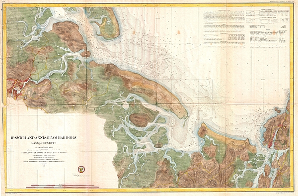
A rare hand colored 1857 nautical chart of the Ipswich and Annisquam Harbors. These two important ports are located just north Boston near Cape Ann.... more
Ships Within
3 - 4 business days
Protect your iPhone X with an impact-resistant, slim-profile, hard-shell case. The image is printed directly onto the case and wrapped around the edges for a beautiful presentation. Simply snap the case onto your iPhone X for instant protection and direct access to all of the phone's features!
Average Rating (4.69 Stars):


Robert Naile
April 21st, 2024

Just what I wanted for a new iPhone. A special “Thank You” to artist ‘Serge Averbukh’ for the addition, at my request, to the design of my Navy rating, the lightening bolts (sparks as they are/were called) in the middle of the CPO insignia. I asked; he came through….When I use my phone, it brings back fond memories of my 20-year Navy career…. Thanks Serge….
Kenneth Kopf
April 21st, 2024

Product is as advertised.. Not impressed with the time it took with shipping. could be the USPS service..
Eleni Fosses
April 20th, 2024

Love the iPhone case. Takes me back to Greece every time I look at it. I have received many compliments
Beverly Jackson
April 20th, 2024

Love, love this one of a kind beautiful phone case so much that I ordered a spare! Thank you.
Suzanne Hale
April 19th, 2024

Looks fantastic, fits my phone perfectly - love it!
Suzanne Hale
April 19th, 2024

Fits my phone perfectly and looks fantastic.
A rare hand colored 1857 nautical chart of the Ipswich and Annisquam Harbors. These two important ports are located just north Boston near Cape Ann. Both were centers of for the cod fishing and whaling industries in the 18th and 19th centuries. Today they are popular tourist destinations. The chart itself covers from Ipswich in the west to Annisquam in the east, shows the various bays and estuaries in between. Unlike many coastal charts, this example also has significant inland detail, showing roads, towns, farms, and some topographical features. Countless depth soundings throughout. Sailing instructions and notes on tides and magnetic variation appear in the upper right quadrant. The triangulation for this nautical chart was completed by C.O. Boutelle. The Topography is the world of H. L Whiting. The hydrography was accomplished by parties under the command of M. Woodhull, S. D. Trenchard, and C. R. P. Rodgers. Published under the supervision of A. D. Bache for the 1853 Report of the...
My passion is Photography and Aviation or is that Aviation and Photography ! I hope you enjoy my photographs.

Our return policy is very simple:
If you're not happy with a purchase that you made on Pixels.com, for any reason, you can return it to us within 30 days of the order date. As soon as it arrives, we'll issue a full refund for the entire purchase price. Please note - Pixels does not reimburse the outgoing or return shipping charges unless the return is due to a defect in quality.
Pixels sells thousands of pieces of artwork each month - all with a 100% money-back guarantee. We take great pride in the fact that hundreds of thousands of artists have chosen Pixels to fulfill their orders, and we look forward to helping you select your next piece!
All iphone x cases ship from our production facility within 3 - 4 business days of your order.
$27.00


There are no comments for 1857 Coast Survey Map of Ipswich and Annisquam, Massachusetts. Click here to post the first comment.