
Frame
Top Mat

Bottom Mat

Dimensions
Image:
8.00" x 2.00"
Overall:
10.00" x 4.00"
New York Subway Map Art Print
Product Details
New York Subway Map art print by Library Of Congress, Geography And Map Division. Our art prints are produced on acid-free papers using archival inks to guarantee that they last a lifetime without fading or loss of color. All art prints include a 1" white border around the image to allow for future framing and matting, if desired.
Design Details
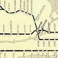
New York subway map. 1918 map of the 'New Subway of Greater New York', New York, USA. It shows the lines serving the west and east sides of Manhattan... more
Ships Within
3 - 4 business days
Additional Products
Art Print Tags
Photograph Tags
Comments (0)
About Art Prints


All prints ship in durable cardboard tubes.
Pixels is one of the largest, most-respected giclee printing companies in the world with over 40 years of experience producing museum-quality prints. All of our art prints are produced on state-of-the-art, professional-grade Epson printers.
We use acid-free papers and canvases with archival inks to guarantee that your art prints last a lifetime without fading or loss of color. Paper prints include a 1" white border around the image to allow for future framing and matting. Canvas prints include a 2.5" white border to allow for future stretching on stretcher bars.
Art prints ship within 3 - 4 business days in durable cardboard tubes.
Art Print Reviews (21229)
Average Rating (4.64 Stars):


Susan Beatty
April 26th, 2024

This print is beautiful. It's a commonly depicted subject, but it is very special. The composition, tonal quality, and movement are exceptional and evocative. The piece is true to it's title... breathtaking!
Dorothy Hasson
April 26th, 2024

I think that this print is beautiful. I bought it for my new house (Oct 24), and have not had it framed yet,
Rosa Berbert
April 26th, 2024

Love this photo! Reminds me of a recent trip to Steamboat Springs- snow- covered trees were beautiful!
Tammy Gammon
April 26th, 2024

High quality image.
Jude Wright
April 26th, 2024

Love it 💜
Annette Wilcox
April 26th, 2024

I have wanted this for my pro life bulletin board at my Catholic Church and I wasn’t disappointed. It is beautiful and it has so much meaning put in a picture. A picture speaks better then words and this picture says it all. Thanks
Artist's Description
New York subway map. 1918 map of the 'New Subway of Greater New York', New York, USA. It shows the lines serving the west and east sides of Manhattan Island, with branches to Brooklyn and Queens (upper right) and to the Bronx (centre left) across the Harlem River. The New York City Subway's first line began operating in 1904. The lines here include ones operated by the Brooklyn Rapid Transit Company and the Interborough Rapid Transit Company. Some of the lines are elevated railways, some are underground railways, and some are rapid transit and express and local services. This map is from the Manhattan Publishing Company.
About Library Of Congress, Geography And Map Division

Science Photo Library (SPL) is the leading source of science images and footage. Sourced from scientific and medical experts, acclaimed photographers and renowned institutions, our content is unrivaled worldwide. Outstanding quality, accuracy and commitment to excellence are deeply embedded in our DNA. Science Photo Library inspires creative professionals and delivers engaging content of the highest quality for a wide range of clients in a variety of sectors. Visit sciencephoto.com for more information and stay connected on Twitter, LinkedIn, Instagram and Vimeo.
Shop with Confidence

Our return policy is very simple:
If you're not happy with a purchase that you made on Pixels.com, for any reason, you can return it to us within 30 days of the order date. As soon as it arrives, we'll issue a full refund for the entire purchase price. Please note - Pixels does not reimburse the outgoing or return shipping charges unless the return is due to a defect in quality.
Pixels sells thousands of pieces of artwork each month - all with a 100% money-back guarantee. We take great pride in the fact that hundreds of thousands of artists have chosen Pixels to fulfill their orders, and we look forward to helping you select your next piece!
Delivery
All art prints ship from our production facility within 3 - 4 business days of your order.
$44.56


There are no comments for New York Subway Map. Click here to post the first comment.