Looking for design inspiration? Browse our curated collections!

Boundary: Bleed area may not be visible.

The watermark at the lower right corner of the image will not appear on the final product.

by Paul Fearn
$35.00
Size
Orientation
Image Size
Product Details
Our luxuriously soft beach towels are made from brushed microfiber with a 100% cotton back for extra absorption. The top of the towel has the image printed on it, and the back is white cotton. Our beach towels are available in two different sizes: beach towel (32" x 64") and beach sheet (37" x 74").
Don't let the fancy name confuse you... a beach sheet is just a large beach towel.
Design Details
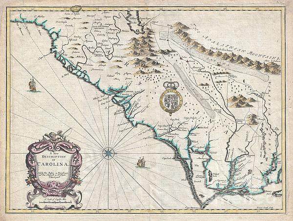
A beautiful example of John Speed's important 1676 map of the Carolina colony. Heavily based upon the explorations of John Lederer and Ogilby's Lords... more
Care Instructions
Machine wash cold and tumble dry with low heat.
Ships Within
1 - 2 business days
Average Rating (4.04 Stars):


Thomas Carroll
April 24th, 2024

Beautiful detailed movie themed towel!
Leesa Odom
April 16th, 2024

I bought this for my grandson. He fell in love with it. He even slept with it. It is a super good quality. Very impressed with image on the towel.
Kenneth Figueroa
April 13th, 2024

So it’s a gift for my dad and haven’t gave it to him yet but we FaceTime and he loved it … I was so worried about ordering here cuz never heard of the company but I’m so glad I did and it came out perfect perfect perfect.
Michele Long
April 13th, 2024

Super happy how print came out, but looks a little less vibrant even after just a cool water quick wash. Still nice looking, but would have preferred the vibrancy to have remained.
Michele Long
April 13th, 2024

Came out really nice! Laundered pretty well too!
Tracey McGraw
April 9th, 2024

Love it. I can't wait to take it on hoilday
A beautiful example of John Speed's important 1676 map of the Carolina colony. Heavily based upon the explorations of John Lederer and Ogilby's Lords Proprietor's Map of 1674. This seminal map represents one of the earliest attempts to map the Carolina interior. Oriented to the West, map covers from the Spanish colony of St. Augustine, Florida, north to Jamestown, Virginia. Extends inland as far as the Appellation (Apalathean) Mountains. By the middle of the 17th century the coast of Carolina had been fairly well mapped , St. Augustine, Port Royal, Charleston (Charles Town), Cape Fear, Cape Lookout, Cape Hatteras, Roanoke, Cape Henry and the James River are all shown with a fair approximation of accuracy. We see ample evidence of the Lords Proprietors including Albemarl County, Clarendon County, Berkley County, Craven County, etc. This map also incorporates numerous elements from earlier maps including Lake Sarrope, which was identified by the De Bry - Le Moyne map of 1565 and most lik...
My passion is Photography and Aviation or is that Aviation and Photography ! I hope you enjoy my photographs.

Our return policy is very simple:
If you're not happy with a purchase that you made on Pixels.com, for any reason, you can return it to us within 30 days of the order date. As soon as it arrives, we'll issue a full refund for the entire purchase price. Please note - Pixels does not reimburse the outgoing or return shipping charges unless the return is due to a defect in quality.
Pixels sells thousands of pieces of artwork each month - all with a 100% money-back guarantee. We take great pride in the fact that hundreds of thousands of artists have chosen Pixels to fulfill their orders, and we look forward to helping you select your next piece!
All beach towels ship from our production facility within 1 - 2 business days of your order.
$35.00


There are no comments for 1676 John Speed Map of Carolina. Click here to post the first comment.