Looking for design inspiration? Browse our curated collections!

Boundary: Bleed area may not be visible.

The watermark at the lower right corner of the image will not appear on the final product.

by Paul Fearn
$35.00
Size
Orientation
Image Size
Product Details
Our luxuriously soft beach towels are made from brushed microfiber with a 100% cotton back for extra absorption. The top of the towel has the image printed on it, and the back is white cotton. Our beach towels are available in two different sizes: beach towel (32" x 64") and beach sheet (37" x 74").
Don't let the fancy name confuse you... a beach sheet is just a large beach towel.
Design Details
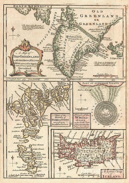
A singularly fascinating 1747 map of Greenland, Iceland and the Faroe Islands by E. Bowen. Essentially four maps on one sheet, this map of the North... more
Care Instructions
Machine wash cold and tumble dry with low heat.
Ships Within
1 - 2 business days
Average Rating (4.04 Stars):


Thomas Carroll
April 24th, 2024

Beautiful detailed movie themed towel!
Leesa Odom
April 16th, 2024

I bought this for my grandson. He fell in love with it. He even slept with it. It is a super good quality. Very impressed with image on the towel.
Kenneth Figueroa
April 13th, 2024

So it’s a gift for my dad and haven’t gave it to him yet but we FaceTime and he loved it … I was so worried about ordering here cuz never heard of the company but I’m so glad I did and it came out perfect perfect perfect.
Michele Long
April 13th, 2024

Super happy how print came out, but looks a little less vibrant even after just a cool water quick wash. Still nice looking, but would have preferred the vibrancy to have remained.
Michele Long
April 13th, 2024

Came out really nice! Laundered pretty well too!
Tracey McGraw
April 9th, 2024

Love it. I can't wait to take it on hoilday
A singularly fascinating 1747 map of Greenland, Iceland and the Faroe Islands by E. Bowen. Essentially four maps on one sheet, this map of the North Atlantic islands is festooned with speculation and curiosities. The uppermost map is based on reports by the priest Hans Egede and shows the southern portions of Greenland as well as parts of Iceland and James Island. When this map was drawn the coasts of Greenland were fairly well mapped out by Icelandic and Scandinavian whalers, but the interior was largely unknown. There was some speculation in the early 17th and 18th centuries that a water passage existed through Greenland providing easy access to Iceland from the Davis Straights. Our map notes the passage but also comments that it is now impassable due to ice. Bowen also notes that the seas on either side of the Island are treacherous due to mountains of Ice. The lower left map depicts the Faroe Islands. Today these stunning green islands are considered one of the most beautiful and u...
My passion is Photography and Aviation or is that Aviation and Photography ! I hope you enjoy my photographs.

Our return policy is very simple:
If you're not happy with a purchase that you made on Pixels.com, for any reason, you can return it to us within 30 days of the order date. As soon as it arrives, we'll issue a full refund for the entire purchase price. Please note - Pixels does not reimburse the outgoing or return shipping charges unless the return is due to a defect in quality.
Pixels sells thousands of pieces of artwork each month - all with a 100% money-back guarantee. We take great pride in the fact that hundreds of thousands of artists have chosen Pixels to fulfill their orders, and we look forward to helping you select your next piece!
All beach towels ship from our production facility within 1 - 2 business days of your order.
$35.00


There are no comments for 1747 Bowen Map of the North Atlantic Islands Greenland Iceland Faroe Islands. Click here to post the first comment.