Looking for design inspiration? Browse our curated collections!


The watermark at the lower right corner of the image will not appear on the final product.

by Paul Fearn
$28.00
Design Location
Color
Image Size
Product Details
Our Bella / Canvas t-shirts are made from a 50% cotton / 50% polyester blend and are available in five different sizes. All t-shirts are machine washable.
Design Details
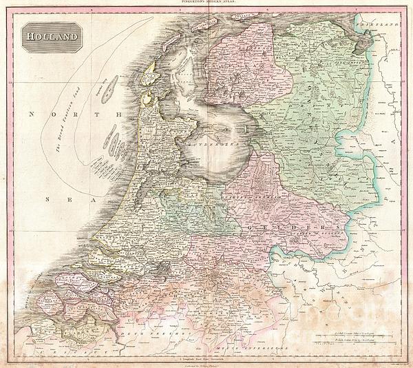
Pinkerton's extraordinary 1818 map of Holland. Covers what is essentially today's Netherlands between the Belgium and Germany. Offers excellent... more
Ships Within
1 - 2 business days
Average Rating (4.34 Stars):


Sherrie Yarbro
April 26th, 2024

We loved the T- shirt but needed the print for a cover for my husbands prosthetic leg. He was in an awful accident a year and lost a leg as a result. He is a Beatle Fanatic and we had to put them on his new leg. Thanks for the awesome art and it was the perfect size.
Suzanne Hale
April 19th, 2024

Very original shirt, lots of compliments- great fit.
Dana Frederickson
April 19th, 2024

This is an excellent t-shirt! An excellent view of an SAS Connect Airbus A320-251N coming in for a landing! I especially wanted to buy this t-shirt because I am of Swedish descent! Excellent photography and artwork!
Dana Frederickson
April 19th, 2024

This is an excellent t-shirt! An excellent view of a P I A Boeing 777 coming in for a landing! The t-shirt came out great! Excellent photography and artwork!
Dean Will
April 18th, 2024

Very pleased with the item!! But wrong color.
Simon Brown
April 13th, 2024

Great but Jaws fans saying it's spelt Pippit
Pinkerton's extraordinary 1818 map of Holland. Covers what is essentially today's Netherlands between the Belgium and Germany. Offers excellent undersea detail regarding various shoals and other dangers, including the Broad Fourteen Sand. Also shows the elaborate system of canals and irrigation networks throughout the region. Offers considerable detail with political divisions and color coding at the regional level. Identifies cities, towns, castles, important battle sites, castles, swamps, mountains and river ways. Title plate in the upper left quadrant. Two mile scales, in Dutch and German Miles and British Statute Miles, also appear in the lower right quadrant. Drawn by L. Herbert and engraved by Samuel Neele under the direction of John Pinkerton. This map comes from the scarce American edition of Pinkerton’s Modern Atlas, published by Thomas Dobson & Co. of Philadelphia in 1818.
My passion is Photography and Aviation or is that Aviation and Photography ! I hope you enjoy my photographs.

Our return policy is very simple:
If you're not happy with a purchase that you made on Pixels.com, for any reason, you can return it to us within 30 days of the order date. As soon as it arrives, we'll issue a full refund for the entire purchase price. Please note - Pixels does not reimburse the outgoing or return shipping charges unless the return is due to a defect in quality.
Pixels sells thousands of pieces of artwork each month - all with a 100% money-back guarantee. We take great pride in the fact that hundreds of thousands of artists have chosen Pixels to fulfill their orders, and we look forward to helping you select your next piece!
All t-shirts ship from our production facility within 1 - 2 business days of your order.
$28.00


There are no comments for 1818 Pinkerton Map of Holland or the Netherlands. Click here to post the first comment.