Looking for design inspiration? Browse our curated collections!

Boundary: Bleed area may not be visible.

Inside Message (Optional)
Inside View
$30.00
Quantity
The more you buy... the more you save.
Orientation
Image Size
Product Details
Our greeting cards are 5" x 7" in size and are produced on digital offset printers using 100 lb. paper stock. Each card is coated with a UV protectant on the outside surface which produces a semi-gloss finish. The inside of each card has a matte white finish and can be customized with your own message up to 500 characters in length. Each card comes with a white envelope for mailing or gift giving.
Design Details
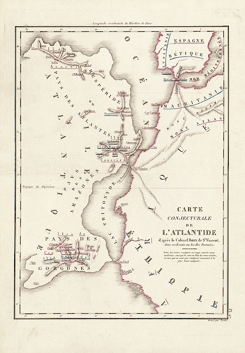
Map of Atlantis. 19th-century map showing a conjectural depiction of a great landmass off north-western Africa, the legendary continent of Atlantis.... more
Ships Within
2 - 3 business days
Average Rating (4.84 Stars):


Constance Harper
April 26th, 2024

Very beautiful painting! Love the greeting cards!
Paul Cutright
April 25th, 2024

I loved the card. Message inside was perfect (just like I requested) Only comment - the picture seemed too large for the card (glue showing on the side) Next time I will down size the picture. I have ordered many cards from fineartamerica and have been very pleased with the artist selection and quality of the art. Paul Cutright
Sitara Laurenti
April 25th, 2024

Gorgeous!! rich colors, lovely glossy finish.
Sitara Laurenti
April 25th, 2024

Beautiful..lovely gloss finish, vibrant colors and amazing details
Kathleen Sanford
April 24th, 2024

Loved this! Colors not quite as bright as what you are showing but I still loved it!
Kathleen Sanford
April 24th, 2024

I thought the colors could have been a little brighter but I was happy with the product!
Map of Atlantis. 19th-century map showing a conjectural depiction of a great landmass off north-western Africa, the legendary continent of Atlantis. Plato made the first written references to Atlantis in 360 BC. Legend has it that Atlantis was destroyed by a great flood and was submerged beneath the sea around 9600 BC. On this map, three Atlantic island groups are shown as tips of mountains remaining after Atlantis sunk. They are: the Azores (top left), the Canary Islands (upper left), and the Cape Verde Islands (lower left). This map is based on 'Essais sur les Iles Fortunees' (1804) by French naturalist Jean Baptiste Bory de Saint-Vincent (1778-1846).

Science Photo Library (SPL) is the leading source of science images and footage. Sourced from scientific and medical experts, acclaimed photographers and renowned institutions, our content is unrivaled worldwide. Outstanding quality, accuracy and commitment to excellence are deeply embedded in our DNA. Science Photo Library inspires creative professionals and delivers engaging content of the highest quality for a wide range of clients in a variety of sectors. Visit sciencephoto.com for more information and stay connected on Twitter, LinkedIn, Instagram and Vimeo.

Our return policy is very simple:
If you're not happy with a purchase that you made on Pixels.com, for any reason, you can return it to us within 30 days of the order date. As soon as it arrives, we'll issue a full refund for the entire purchase price. Please note - Pixels does not reimburse the outgoing or return shipping charges unless the return is due to a defect in quality.
Pixels sells thousands of pieces of artwork each month - all with a 100% money-back guarantee. We take great pride in the fact that hundreds of thousands of artists have chosen Pixels to fulfill their orders, and we look forward to helping you select your next piece!
All greeting cards ship from our production facility within 2 - 3 business days of your order.
$30.00


There are no comments for Map Of Atlantis. Click here to post the first comment.